
Mapa topográfico Laage
Mapa interactivo
Haga clic en el mapa para ver la altitud.
Laage
To the west and east of the Recknitz-Urstromtal there are terminal moraines. Der Kalte Berg is 62m above the Normalhöhennull, the tallest point of elevation in the municipal area. Rostock Laage Airport is located a few kilometers west of Laage.
Acerca de este mapa
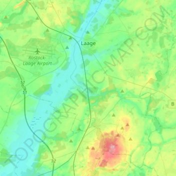
Nombre: Mapa topográfico Laage, altitud, relieve.
Altitud media: 39 m
Altitud mínima: 8 m
Altitud máxima: 127 m