
Mapa topográfico Chorin
Mapa interactivo
Haga clic en el mapa para ver la altitud.
Acerca de este mapa
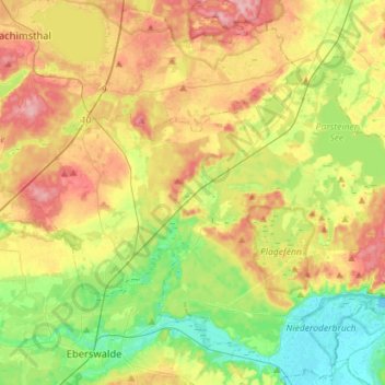
Nombre: Mapa topográfico Chorin, altitud, relieve.
Lugar: Chorin, Britz-Chorin-Oderberg, Barnim, Brandenburg, Germany (52.84611 13.74332 52.96747 14.02713)
Altitud media: 55 m
Altitud mínima: -2 m
Altitud máxima: 125 m
Otros mapas topográficos
Haga clic en un mapa para ver su topografía, su altitud y su relieve.
Ahrensfelde
Germany > Brandenburg > Barnim
Ahrensfelde, Barnim, Brandenburg, 16356, Germany
Altitud media: 67 m
Bernau bei Berlin
Germany > Brandenburg > Barnim > Bernau > Bernau bei Berlin
Bernau bei Berlin, Bernau, Barnim, Brandenburg, 16321, Germany
Altitud media: 77 m
Biesenthal
Germany > Brandenburg > Barnim > Biesenthal-Barnim
Biesenthal, Biesenthal-Barnim, Barnim, Brandenburg, 16359, Germany
Altitud media: 59 m