
Mapa topográfico Cagayancillo
Mapa interactivo
Haga clic en el mapa para ver la altitud.
Acerca de este mapa
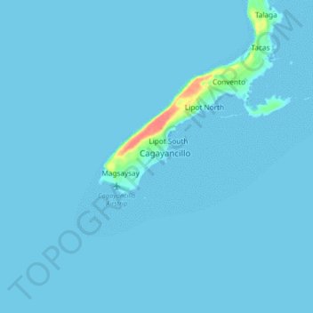
Nombre: Mapa topográfico Cagayancillo, altitud, relieve.
Lugar: Cagayancillo, Palawan, Mimaropa, 5321, Philippines (9.53691 121.15715 9.61691 121.23715)
Altitud media: 2 m
Altitud mínima: 0 m
Altitud máxima: 61 m
There are neither mountain ranges nor forested areas in the municipality. A hilly portion in the north-eastern part of the main island has a slope of 3-82%. The other areas are flat with the highest elevation around 2 to 3 meters. The majority of the island has a sandy loam soil not enough to support a forest.
Otros mapas topográficos
Haga clic en un mapa para ver su topografía, su altitud y su relieve.
Cagayancillo
Philippines > Palawan > Cagayancillo
Cagayancillo, Palawan, Mimaropa, 5321, Philippines
Altitud media: 0 m