
Haz una donación
Mapa topográfico Lake Desolation
Haga clic en el mapa para ver la altitud.
Haz una donación
Acerca de este mapa
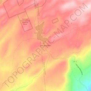
Nombre: Mapa topográfico Lake Desolation, altitud, relieve.
Altitud media: 470 m
Altitud mínima: 259 m
Altitud máxima: 558 m
Haz una donación
Otros mapas topográficos
Haga clic en un mapa para ver su topografía, su altitud y su relieve.
Town of Clifton Park
United States > New York > Saratoga County
Clifton Park features a predominantly gentle terrain characterized by rolling hills and a mixture of forested areas, open fields, and suburban developments. The elevation in this area varies, generally ranging from around 300 to 500 feet above sea level, contributing to a picturesque landscape that integrates…
Altitud media: 85 m
Town of Halfmoon
United States > New York > Saratoga County
Halfmoon is a town in Saratoga County, New York, United States. The population was 25,662 at the 2020 census. The town is apparently named for the shape of the lower elevation land north of the junction of the Hudson and Mohawk Rivers. It is also said to be named for Henry Hudson's ship, the Halve Maen.
Altitud media: 73 m
Haz una donación
Haz una donación
Haz una donación
Village of Waterford
United States > New York > Saratoga County
While much of the surrounding town has a high elevation, the Village of Waterford is very low relative to the two major rivers forming its borders. Its position at the convergence of both the Erie and Champlain Canals as well as the Mohawk and Hudson Rivers, has contributed to many floods. While major floods…
Altitud media: 22 m
Haz una donación
Moreau Lake State Park
United States > New York > Saratoga County > Town of Corinth
Altitud media: 173 m
Haz una donación
Haz una donación
Haz una donación
Saratoga National Historical Park
United States > New York > Saratoga County > Town of Stillwater
Altitud media: 87 m
Haz una donación
Haz una donación
Town of Halfmoon
United States > New York > Saratoga County
Halfmoon is a town in Saratoga County, New York, United States. The population was 25,662 at the 2020 census. The town is apparently named for the shape of the lower elevation land north of the junction of the Hudson and Mohawk Rivers. It is also said to be named for Henry Hudson's ship, the Halve Maen.
Altitud media: 73 m
Haz una donación