
Mapa topográfico Oneida County
Mapa interactivo
Haga clic en el mapa para ver la altitud.
Acerca de este mapa
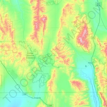
Nombre: Mapa topográfico Oneida County, altitud, relieve.
Lugar: Oneida County, Idaho, United States (41.99724 -113.00008 42.50306 -112.07027)
Altitud media: 1,678 m
Altitud mínima: 1,325 m
Altitud máxima: 2,747 m
Oxford Peak is the highest point in the county at 9,285 ft (2830.2 m) above sea level. Alternating valleys and ridges of mountains or hills typify the topography, with grassland and sagebrush covering most areas. The Curlew National Grassland lies within the county.
Otros mapas topográficos
Haga clic en un mapa para ver su topografía, su altitud y su relieve.
Malad Summit
United States > Idaho > Oneida County
Malad Summit, Oneida County, Idaho, United States
Altitud media: 1,715 m