
Mapa topográfico Inchbrook
Haga clic en el mapa para ver la altitud.
Acerca de este mapa
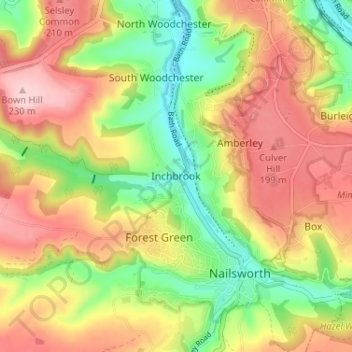
Nombre: Mapa topográfico Inchbrook, altitud, relieve.
Altitud media: 141 m
Altitud mínima: 45 m
Altitud máxima: 233 m
Otros mapas topográficos
Haga clic en un mapa para ver su topografía, su altitud y su relieve.
Alderley
United Kingdom > England > Gloucestershire > Stroud
In A Topographical Dictionary of England by Samuel Lewis published in 1831, Alderley is described thus.
Altitud media: 95 m