
Mapa topográfico Hardeeville
Mapa interactivo
Haga clic en el mapa para ver la altitud.
Acerca de este mapa
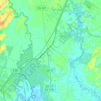
Nombre: Mapa topográfico Hardeeville, altitud, relieve.
Altitud media: 5 m
Altitud mínima: -4 m
Altitud máxima: 27 m
The city is located on the Atlantic coastal plain, with very few variations in elevation. The average elevation of the city is approximately 20 feet (6.1 m) above mean sea level. Most of Hardeeville is located within Jasper County, though a small portion of the city crosses into Beaufort County. Much of the city is bordered to the west by the Savannah National Wildlife Refuge, a large-scale nature preserve along the South Carolina and Georgia sides of the Savannah River.
Otros mapas topográficos
Haga clic en un mapa para ver su topografía, su altitud y su relieve.
Ridgeland
United States > South Carolina > Jasper County
Ridgeland, Jasper County, South Carolina, United States
Altitud media: 15 m
Latitude Margaritaville
United States > South Carolina > Jasper County > Hardeeville
Latitude Margaritaville, Hardeeville, Jasper County, South Carolina, 29927, United States
Altitud media: 4 m