
Haz una donación
Mapa topográfico Madakasira
Haga clic en el mapa para ver la altitud.
Haz una donación
Madakasira
Madakasira is located at 13°56′13″N 77°16′10″E / 13.9369°N 77.2694°E / 13.9369; 77.2694. It has an average elevation of 676 metres (2221 ft). The height of the Madakasira hill is 2936 feet from the Sea Level.Formerly Madakasira is called as SIMHAGIRI because hill from one side looks like a sleeping lion. Around Madakasira there are numerous isolated Peaks and Rocky Clusters which are devoid of any vegetation. Madakasira town is cooler compared to the climate of elsewhere in Sri Sathya Sai District, hence aptly known as Ooty of Sri Sathya Sai District.
Haz una donación
Acerca de este mapa
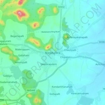
Nombre: Mapa topográfico Madakasira, altitud, relieve.
Lugar: Madakasira, Sri Sathya Sai, Andhra Pradesh, 515300, India (13.90055 77.23259 13.98055 77.31259)
Altitud media: 684 m
Altitud mínima: 633 m
Altitud máxima: 978 m
Haz una donación