
Gracias por apoyar a este sitio ❤️
Haz una donación
Haz una donación
Mapa topográfico Shell
Haga clic en el mapa para ver la altitud.
Gracias por apoyar a este sitio ❤️
Haz una donación
Haz una donación
Acerca de este mapa
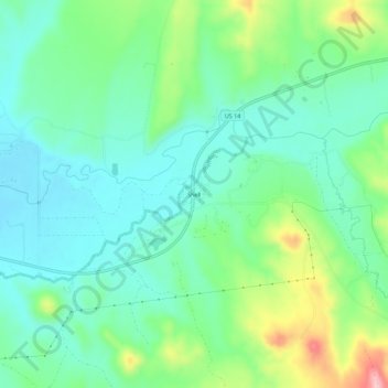
Nombre: Mapa topográfico Shell, altitud, relieve.
Lugar: Shell, Big Horn County, Wyoming, 82441, United States (44.51552 -107.79981 44.55552 -107.75981)
Altitud media: 1,317 m
Altitud mínima: 1,265 m
Altitud máxima: 1,449 m
Gracias por apoyar a este sitio ❤️
Haz una donación
Haz una donación
Otros mapas topográficos
Haga clic en un mapa para ver su topografía, su altitud y su relieve.