
Gracias por apoyar a este sitio ❤️
Haz una donación
Haz una donación
Mapa topográfico Wai
Haga clic en el mapa para ver la altitud.
Gracias por apoyar a este sitio ❤️
Haz una donación
Haz una donación
Wai
Wai is located at 17°56′N 73°53′E / 17.94°N 73.88°E / 17.94; 73.88, approximately 35 km (22 mi) north of the city of Satara. It has an average elevation of 718 metres (2,356 ft). It is surrounded by the mountainous region of the Sahyādris.
Gracias por apoyar a este sitio ❤️
Haz una donación
Haz una donación
Acerca de este mapa
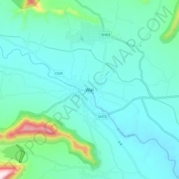
Nombre: Mapa topográfico Wai, altitud, relieve.
Lugar: Wai, Satara, Maharashtra, 412803, India (17.91199 73.85130 17.99199 73.93130)
Altitud media: 762 m
Altitud mínima: 678 m
Altitud máxima: 1,209 m
Gracias por apoyar a este sitio ❤️
Haz una donación
Haz una donación
Otros mapas topográficos
Haga clic en un mapa para ver su topografía, su altitud y su relieve.