
Haz una donación
Mapa topográfico Gurudongmar
Haga clic en el mapa para ver la altitud.
Haz una donación
Gurudongmar
Gurudongmar Lake is one of the highest lakes in the world and in India, at an elevation of 5,430 m (17,800 ft) according to the Government of Sikkim. It is located in the Great Himalayas in the Mangan District in Indian state of Sikkim, and considered sacred by Buddhists and Sikhs. The lake is named after Padmasambhava, who visited it in the 8th century.
Haz una donación
Acerca de este mapa
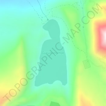
Nombre: Mapa topográfico Gurudongmar, altitud, relieve.
Lugar: Gurudongmar, Chungthang, Mangan, Sikkim, India (28.01845 88.70537 28.03566 88.71481)
Altitud media: 5,232 m
Altitud mínima: 5,074 m
Altitud máxima: 5,598 m
Haz una donación
Otros mapas topográficos
Haga clic en un mapa para ver su topografía, su altitud y su relieve.
Kangchenjunga
India > Sikkim > Chungthang
Kangchenjunga Main is the highest elevation of the Brahmaputra River basin, which forms part of the southeast Asian monsoon regime and is among the globally largest river basins. Kangchenjunga is one of six peaks above 8,000 m (26,000 ft) located in the basin of the Kosi River, which is among the largest…
Altitud media: 7,725 m
Haz una donación
Kangchenjunga
India > Sikkim > Chungthang
Kangchenjunga Main is the highest elevation of the Brahmaputra River basin, which forms part of the southeast Asian monsoon regime and is among the globally largest river basins. Kangchenjunga is one of six peaks above 8,000 m (26,000 ft) located in the basin of the Kosi River, which is among the largest…
Altitud media: 7,725 m
Haz una donación
Lachung
India > Sikkim > Chungthang
Lachung is a town and hill station in northeast Sikkim, India. It is located in the North Sikkim district near the border with Tibet. Lachung is at an elevation of about 9,600 feet (2,900 m) and at the confluence of the Lachen and Lachung Rivers, both tributaries of the River Teesta. The word Lachung means…
Altitud media: 3,617 m