
Gracias por apoyar a este sitio ❤️
Haz una donación
Haz una donación
Mapa topográfico Kheda
Haga clic en el mapa para ver la altitud.
Gracias por apoyar a este sitio ❤️
Haz una donación
Haz una donación
Kheda
Kheda is located at 22°45′N 72°41′E / 22.75°N 72.68°E / 22.75; 72.68. It has an average elevation of 21 metres (68 feet). Kheda is on the banks of Vatrak and Shedhi rivers.
Gracias por apoyar a este sitio ❤️
Haz una donación
Haz una donación
Acerca de este mapa
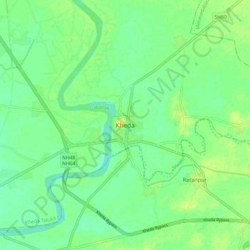
Nombre: Mapa topográfico Kheda, altitud, relieve.
Lugar: Kheda, Kheda Taluka, Kheda, Gujarat, 387400, India (22.71161 72.64572 22.79161 72.72572)
Altitud media: 27 m
Altitud mínima: 18 m
Altitud máxima: 37 m
Gracias por apoyar a este sitio ❤️
Haz una donación
Haz una donación