
Mapa topográfico Oslob
Haga clic en el mapa para ver la altitud.
Oslob
Generally, topography of the area is hilly and rolling, dominated by open grasslands and second growth forest. There are fairly level and rolling plateaus and valleys spread throughout the interior. These are some of the most suitable areas for upland agriculture. The highest mountain peak is 800 metres (2,600 ft) above sea level.
Acerca de este mapa
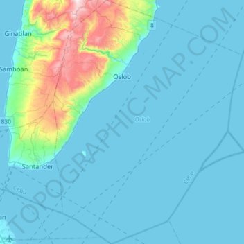
Nombre: Mapa topográfico Oslob, altitud, relieve.
Lugar: Oslob, Cebu, Central Visayas, 6025, Philippines (9.32785 123.35292 9.60805 123.57381)
Altitud media: 99 m
Altitud mínima: 0 m
Altitud máxima: 869 m
Otros mapas topográficos
Haga clic en un mapa para ver su topografía, su altitud y su relieve.