
Haz una donación
Mapa topográfico Dahl
Haga clic en el mapa para ver la altitud.
Haz una donación
Dahl
Dahl liegt südöstlich der Kernstadt Paderborn auf der Paderborner Hochfläche am Westrand des Eggegebirges auf einer Höhe von 218 m ü. NN. Durch das Dorf fließt der Ellerbach.
Haz una donación
Acerca de este mapa
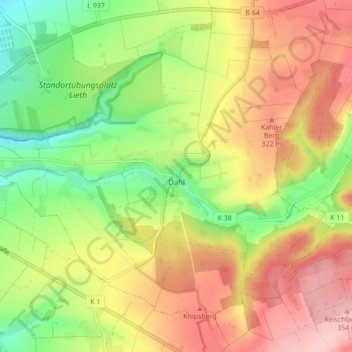
Nombre: Mapa topográfico Dahl, altitud, relieve.
Altitud media: 272 m
Altitud mínima: 183 m
Altitud máxima: 363 m
Haz una donación
Otros mapas topográficos
Haga clic en un mapa para ver su topografía, su altitud y su relieve.
Habichtsee
Deutschland > Nordrhein-Westfalen > Kreis Paderborn > Paderborn > Sennelager
Altitud media: 112 m
Barkhausen
Deutschland > Nordrhein-Westfalen > Kreis Paderborn > Paderborn > Wewer
Altitud media: 139 m
Haz una donación
Tallesee Mittelsee
Deutschland > Nordrhein-Westfalen > Kreis Paderborn > Paderborn
Altitud media: 118 m
Nesthauser See
Deutschland > Nordrhein-Westfalen > Kreis Paderborn > Paderborn > Sande
Altitud media: 101 m