
Mapa topográfico Kent
Haga clic en el mapa para ver la altitud.
Kent
Kent was also the location of the largest number of art schools in the country during the nineteenth century, estimated by the art historian David Haste, to approach two hundred. This is believed to be the result of Kent being a front line county during the Napoleonic Wars. At this time, before the invention of photography, draughtsmen were used to draw maps and topographical representations of the fields of battle, and after the wars ended many of these settled permanently in the county in which they had been based. Once the idea of art schools had been established, even in small towns in Kent, the tradition continued, although most of the schools were very small one man operations, each teaching a small number of daughters of the upper classes how to draw and make watercolour paintings. Nonetheless, some of these small art schools developed into much larger organisations, including Canterbury College of Art, founded by Thomas Sidney Cooper in 1868, which is today the University for the Creative Arts.
Acerca de este mapa
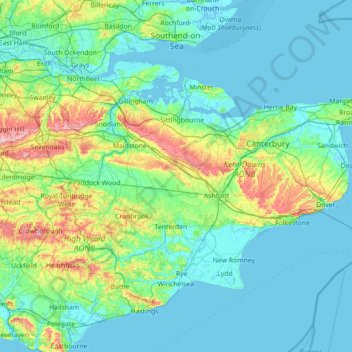
Nombre: Mapa topográfico Kent, altitud, relieve.
Lugar: Kent, South East, England, United Kingdom (50.91048 0.03352 51.48227 1.45177)
Altitud media: 37 m
Altitud mínima: -3 m
Altitud máxima: 263 m
Otros mapas topográficos
Haga clic en un mapa para ver su topografía, su altitud y su relieve.
Brund Fell (summit)
United Kingdom > England > Cumberland > Borrowdale
The fell has a summit plateau which consist of many heather-covered hummocks, drystone walls and clumps of trees. Well-known Lake District writer Alfred Wainwright credits Grange Fell as a single fell with three main summits, namely Brund Fell, King's How and Ether Knott. The lesser known Ether Knott is now…
Altitud media: 252 m
Stoke-on-Trent
United Kingdom > England > Stoke-on-Trent > Stoke-on-Trent
In 1919, the borough proposed to expand further and annex the neighbouring borough of Newcastle-under-Lyme and the Wolstanton United Urban District, both to the west of Stoke. This never took place, due to strong objections from Newcastle Corporation. A further attempt was made in 1930, with the promotion of…
Altitud media: 160 m
Bradford
Bradford is located at 53°45′00″N 01°50′00″W / 53.75000°N 1.83333°W / 53.75000; -1.83333 (53.7500, -1.8333)1. Topographically, it is located in the eastern moorland region of the South Pennines.
Altitud media: 167 m
Farnborough
United Kingdom > England > Hampshire > Rushmoor
Farnborough is located in the northeastern corner of the county of Hampshire, near the border with Surrey. The town occupies a valley setting, with the main urban area situated between the River Blackwater to the east and higher ground to the west. The topography gradually rises from the valley floor, reaching…
Altitud media: 82 m
Plymouth
United Kingdom > England > Devon > Plymouth
The River Plym, which flows off Dartmoor to the north-east, forms a smaller estuary to the east of the city called Cattewater. Plymouth Sound is protected from the sea by the Plymouth Breakwater, in use since 1814. In the Sound is Drake's Island which is seen from Plymouth Hoe, a flat public area on top of…
Altitud media: 81 m
Cambridge
United Kingdom > England > Cambridge
The city, like most of the UK, has a maritime climate highly influenced by the Gulf Stream. Located in the driest region of Britain, Cambridge's rainfall averages around 570 mm (22.44 in) per year, around half the national average, with some years occasionally falling into the semi-arid (under 500 mm (19.69…
Altitud media: 18 m
Hull
United Kingdom > England > Kingston upon Hull
Kingston upon Hull is on the northern bank of the Humber Estuary. The city centre is west of the River Hull and close to the Humber. The city is built upon alluvial and glacial deposits which overlie chalk rocks but the underlying chalk has no influence on the topography. The land within the city is generally…
Altitud media: 21 m
Peterborough
United Kingdom > England > Cambridgeshire
The local topography is flat, and in some places, the land lies below sea level, for example in parts of the Fens to the east and to the south of Peterborough. Human settlement in the area began before the Bronze Age, as can be seen at the Flag Fen archaeological site to the east of the current city centre,…
Altitud media: 17 m
St Albans
United Kingdom > England > Hertfordshire > St Albans
St Albans was an ancient borough created following the dissolution of the monastery in 1539. It consisted of the ancient parish of St Albans (also known as the Abbey parish) and parts of St Michael and St Peter. The municipal corporation was reformed by the Municipal Corporations Act 1835 and the boundary was…
Altitud media: 100 m
Hardknott Pass
United Kingdom > England > Cumberland > Ulpha
The Hardknott Pass stands at a maximum elevation of 393 m (1,289 ft). The road descends steeply at a gradient of 30% (1 in 3) into the Duddon Valley. At the eastern end of the pass is Cockley Beck farm, built in the 1860s and owned by the National Trust. The route from Hardknott leads eastward towards the…
Altitud media: 323 m
City of London
United Kingdom > England > City of London > City of London
The elevation of the City ranges from sea level at the Thames to 21.6 metres (71 ft) at the junction of High Holborn and Chancery Lane. Two small but notable hills are within the historic core, Ludgate Hill to the west and Cornhill to the east. Between them ran the Walbrook, one of the many "lost" rivers or…
Altitud media: 42 m
Catcliffe
United Kingdom > England > Rotherham
The Catcliffe Glass Cone, part of the previous William Fenney's glassworks, is on Main Street. The centre of the village is dominated by a nine-arch viaduct that was built in 1901 to carry the Sheffield District Railway across the River Rother. Catcliffe Flash, to the south of the village, is a local nature…
Altitud media: 58 m
Pennines
United Kingdom > England > Westmorland and Furness
The Pennine climate is generally temperate like that of the rest of England, but the hills have more precipitation, stronger winds and colder weather than the surrounding areas. Higher elevations have a tundra climate. More snow falls on the Pennines than on surrounding lowland areas due to the elevation and…
Altitud media: 761 m
Leeds
Lying in the eastern foothills of the Pennines, there is a significant variation in elevation within the city's built-up area. The district ranges from 1,115 feet (340 m) in the far west on the slopes of Ilkley Moor to about 33 feet (10 m) where the rivers Aire and Wharfe cross the eastern boundary. Land rises…
Altitud media: 94 m
Stratton Brook
United Kingdom > England > Surrey > Tandridge > Godstone > Church Town
Altitud media: 117 m
Treeton
United Kingdom > England > Rotherham
Catcliffe Flash, to the west of the village, is a local nature reserve that is made up of a lake and marshland formed as the elevation of the land beside the River Rother dropped due to coal mining subsidence. To the south-east of the village are three areas of ancient woodland, Treeton Wood, Hail Mary Hill…
Altitud media: 58 m
Newcastle-under-Lyme
United Kingdom > England > Staffordshire > Newcastle-under-Lyme
Altitud media: 147 m
West Byfleet
United Kingdom > England > Surrey > Woking
The surface undulates gently from the west to the east, where West Byfleet's land is drained in the parish of Byfleet itself by the River Wey. Soil ranges from sandy acidic soil in the west to more alluvial soil in the east, underlain by a mixture of gravel and clay. Elevations range from 18m Above Ordnance…
Altitud media: 26 m
Amble
United Kingdom > England > Northumberland
Samuel Lewis reported a township population of 247 in 1831. By the seventh edition of his Topographical Dictionary of England, which was published in 1848, this figure had risen to 724. The population was reported as being 1,040 in 1851. The 1871 census recorded a population of 1,233, spread among 233 houses.
Altitud media: 15 m
Kings Heath
United Kingdom > England > West Midlands Combined Authority > Birmingham > Kings Heath
Altitud media: 142 m