
Mapa topográfico Sudarshan Parbat
Haga clic en el mapa para ver la altitud.
Sudarshan Parbat
Sudarshan Parbat is a mountain of the Garhwal Himalaya in Uttarakhand India.The elevation of Sudarshan Parbat is 6,529 metres (21,421 ft) and its prominence is 456 metres (1,496 ft). It is joint 87th highest located entirely within the Uttrakhand. Nanda Devi, is the highest mountain in this category. Sudarshan Parbat lies 2.1 km south of Chaturbhuj 6,654 metres (21,831 ft) and 3.3 km west of Shyamvarn 6,135 metres (20,128 ft). Its nearest higher neighbor Chaturbhuj. It is located 3.7 km SW of Yogeshwar 6,678 metres (21,909 ft) and 9.9 km SW lies Manda I 6,511 metres (21,362 ft).
Acerca de este mapa
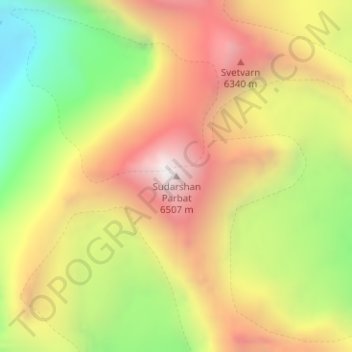
Nombre: Mapa topográfico Sudarshan Parbat, altitud, relieve.
Lugar: Sudarshan Parbat, Bhatwari, Uttarkashi, Uttarakhand, India (30.97671 79.09398 30.97681 79.09408)
Altitud media: 5,792 m
Altitud mínima: 5,025 m
Altitud máxima: 6,494 m
Otros mapas topográficos
Haga clic en un mapa para ver su topografía, su altitud y su relieve.