
Gracias por apoyar a este sitio ❤️
Haz una donación
Haz una donación
Mapa topográfico Leofels
Haga clic en el mapa para ver la altitud.
Gracias por apoyar a este sitio ❤️
Haz una donación
Haz una donación
Acerca de este mapa
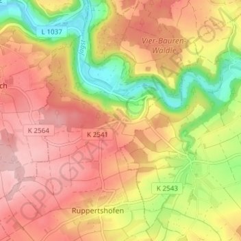
Nombre: Mapa topográfico Leofels, altitud, relieve.
Altitud media: 406 m
Altitud mínima: 303 m
Altitud máxima: 480 m
Gracias por apoyar a este sitio ❤️
Haz una donación
Haz una donación
Otros mapas topográficos
Haga clic en un mapa para ver su topografía, su altitud y su relieve.
Obersteinach
Deutschland > Baden-Württemberg > Landkreis Schwäbisch Hall > Ilshofen
Altitud media: 443 m