
Mapa topográfico Park City
Mapa interactivo
Haga clic en el mapa para ver la altitud.
Acerca de este mapa
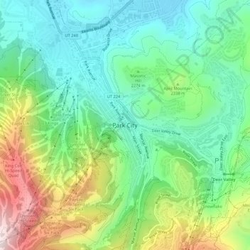
Nombre: Mapa topográfico Park City, altitud, relieve.
Lugar: Park City, Summit County, Utah, 84060, United States (40.60609 -111.53800 40.68609 -111.45800)
Altitud media: 2,315 m
Altitud mínima: 1,961 m
Altitud máxima: 3,042 m
In the summertime, many valley residents of the Wasatch Front visit the town to escape high temperatures. Park City is usually cooler than Salt Lake City as it lies mostly higher than 7,000 feet (2,100 m) above sea level, while Salt Lake City is situated at an elevation of about 4,300 feet (1,300 m).