
Mapa topográfico Sindangan
Haga clic en el mapa para ver la altitud.
Sindangan
Since its elevation to a municipality in 1936, people from Luzon and the Visayas continued migrating to Sindangan to settle together with their families and built businesses. That is why aside from the Subanens, there are Sindanganons whose origins are from Bohol, Cebu, Samar, Leyte, Negros, Bicol, Pampanga, and Manila.
Acerca de este mapa
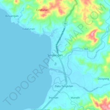
Nombre: Mapa topográfico Sindangan, altitud, relieve.
Altitud media: 30 m
Altitud mínima: -2 m
Altitud máxima: 220 m
Otros mapas topográficos
Haga clic en un mapa para ver su topografía, su altitud y su relieve.