
Mapa topográfico Pine Valley Mountain Wilderness
Mapa interactivo
Haga clic en el mapa para ver la altitud.
Acerca de este mapa
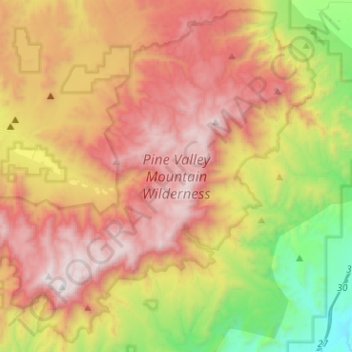
Nombre: Mapa topográfico Pine Valley Mountain Wilderness, altitud, relieve.
Altitud media: 2,125 m
Altitud mínima: 1,117 m
Altitud máxima: 3,147 m
Pine Valley Mountain Wilderness is a 50,232-acre (203.28 km2) wilderness area located in the Dixie National Forest in the U.S. state of Utah. It is the fourth-largest wilderness area located entirely within the state (following the High Uintas Wilderness, Zion Wilderness, and Cedar Mountain Wilderness). The wilderness designation protects the Pine Valley Mountain range, a large rock outcrop surrounded by desert. The Pine Valley Mountains form the Pine Valley Laccolith, one of the largest laccoliths in the United States. Elevations in the wilderness range from 6,000 feet (1,800 m) to 10,365 feet (3,159 m) at the summit of Signal Peak.
Otros mapas topográficos
Haga clic en un mapa para ver su topografía, su altitud y su relieve.
Springdale
United States > Utah > Washington County
Springdale, Washington County, Utah, 84767, United States
Altitud media: 1,354 m
Saint George
United States > Utah > Washington County
Saint George, Washington County, Utah, United States
Altitud media: 929 m
Cottonwood Canyon Wilderness
United States > Utah > Washington County > Washington
Cottonwood Canyon Wilderness, Washington, Washington County, Utah, United States
Altitud media: 1,213 m
Toquerville
United States > Utah > Washington County
Toquerville, Washington County, Utah, 84774, United States
Altitud media: 1,301 m
Hurricane
United States > Utah > Washington County
Hurricane, Washington County, Utah, United States
Altitud media: 1,154 m
Ivins
United States > Utah > Washington County > Ivins
Ivins, Washington County, Utah, 84738, United States
Altitud media: 1,007 m
Zion National Park
United States > Utah > Washington County
Zion National Park, Washington County, Utah, United States
Altitud media: 1,877 m