
Mapa topográfico Dassel
Mapa interactivo
Haga clic en el mapa para ver la altitud.
Acerca de este mapa
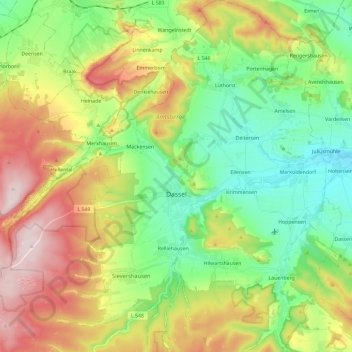
Nombre: Mapa topográfico Dassel, altitud, relieve.
Lugar: Dassel, Landkreis Northeim, Lower Saxony, 37586, Germany (51.73707 9.57882 51.88157 9.79949)
Altitud media: 277 m
Altitud mínima: 121 m
Altitud máxima: 531 m
Otros mapas topográficos
Haga clic en un mapa para ver su topografía, su altitud y su relieve.
Bodenfelde
Germany > Lower Saxony > Landkreis Northeim
Bodenfelde, Landkreis Northeim, Lower Saxony, 37194, Germany
Altitud media: 237 m
Uslar
Germany > Lower Saxony > Landkreis Northeim
Uslar, Landkreis Northeim, Lower Saxony, 37170, Germany
Altitud media: 269 m
Clus
Germany > Lower Saxony > Landkreis Northeim > Bad Gandersheim
Clus, Bad Gandersheim, Landkreis Northeim, Lower Saxony, 37581, Germany
Altitud media: 169 m
Balos
Germany > Lower Saxony > Landkreis Northeim > Moringen
Balos, Moringen, Landkreis Northeim, Lower Saxony, 37186, Germany
Altitud media: 293 m