
Haz una donación
Mapa topográfico Whitchurch Park Ward
Haga clic en el mapa para ver la altitud.
Haz una donación
Acerca de este mapa
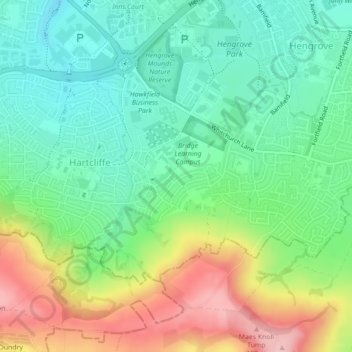
Nombre: Mapa topográfico Whitchurch Park Ward, altitud, relieve.
Altitud media: 91 m
Altitud mínima: 31 m
Altitud máxima: 198 m
Haz una donación
Otros mapas topográficos
Haga clic en un mapa para ver su topografía, su altitud y su relieve.
Castle Park
United Kingdom > England > City of Bristol > Bristol
The main objection to this plan came from the independent traders who did not wish to relocate because they felt that the proposed new shopping area was 'off the beaten track'. This objection was not unreasonable, as in its pre-war topography Bristol had a long shopping axis that started at Stapleton Road to…
Altitud media: 26 m
Haz una donación
Haz una donación
Haz una donación
Oldbury Court Estate/Vassals Park
United Kingdom > England > City of Bristol > Bristol
Altitud media: 56 m
Haz una donación
Moorgrove Wood
United Kingdom > England > City of Bristol > Bristol > Blaise Hamlet
Altitud media: 40 m
Haz una donación