
Haz una donación
Mapa topográfico Keren
Haga clic en el mapa para ver la altitud.
Haz una donación
Keren
Keren (Tigrinya and Tigre: ከረን, Italian: Cheren), historically known as Sanhit, is the second-largest city in Eritrea. It is situated around 91 kilometres (57 mi) northwest of Asmara at an elevation of 1,590 metres (5,220 ft) above sea-level. The city sprawls on a wide basin surrounded by granitic mountains on all sides. It serves as the capital of the Anseba Region, and is home to a number of ethnic groups including the Bilen people and Tigre people.
Haz una donación
Acerca de este mapa
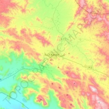
Nombre: Mapa topográfico Keren, altitud, relieve.
Lugar: Keren, Eritrea (15.62048 38.29361 15.94048 38.61361)
Altitud media: 1,456 m
Altitud mínima: 811 m
Altitud máxima: 2,359 m
Haz una donación
Otros mapas topográficos
Haga clic en un mapa para ver su topografía, su altitud y su relieve.
Debub Region
Zoba Debub is one of the six Zobas (Regions) of Eritrea which is located in the southern part of the country with longitude of 38° 15' - 39° 40' East and latitude 14° 25' - 15° 15 North. It shares borders with Zoba Maekel (Central Region) in the north, Zoba Northern Red Sea in the east, Gash Barka in the…
Altitud media: 1,627 m
Haz una donación
Maekel Region
Central is the smallest region in Eritrea, and contains the major city and national capital, Asmara. Maekel is situated inland, and borders Anseba to the north-west, the Northern Red Sea region to the north-east, the Debub (Southern) region to the south, and Gash-Barka to the west. Much of the architecture in…
Altitud media: 1,902 m
Anseba
Anseba region (Tigrinya: ዞባ ዓንሰባ, Arabic: إقليم عنسبا) is an administrative region of Eritrea, located in northern Eritrea. The capital and the most populous city in the region is Keren. The region is named after Anseba River, which passed through most parts of the region. The average…
Altitud media: 749 m
Haz una donación
Gash-Barka
It is situated in the south-west of the country, bordering the Anseba region to the north, and the Maekel (Central) and Debub (Southern) regions to the east; the country of Sudan lies to the west and Ethiopia to the south. The major crops in the region are bananas, tomatoes, cotton, onions, millet, sesame,…
Altitud media: 915 m
Haz una donación
Debub Region
Zoba Debub is one of the six Zobas (Regions) of Eritrea which is located in the southern part of the country with longitude of 38° 15' - 39° 40' East and latitude 14° 25' - 15° 15 North. It shares borders with Zoba Maekel (Central Region) in the north, Zoba Northern Red Sea in the east, Gash Barka in the…
Altitud media: 1,627 m
Haz una donación
Northern Red Sea Region
The Northern Red Sea Region borders the Anseba, Maekel (Central) and Debub (Southern) regions to the west, and the Southern Red Sea Region to the east. It has an area of around 27,800 km2. The lowest point in Eritrea, Lake Kulul, is in this region. The topography of the region has coastal plains, which are…
Altitud media: 534 m
Anseba
Anseba Region (Tigrinya: ዞባ ዓንሰባ, Italian: Regione dell'Anseba) is an administrative region of Eritrea, located in northern Eritrea. The capital and the most populous city in the region is Keren. The region is named after Anseba River, which passed through most parts of the region. The average…
Altitud media: 749 m