
Haz una donación
Mapa topográfico Glenville
Haga clic en el mapa para ver la altitud.
Haz una donación
Acerca de este mapa
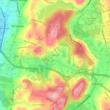
Nombre: Mapa topográfico Glenville, altitud, relieve.
Altitud media: 81 m
Altitud mínima: 1 m
Altitud máxima: 158 m
Haz una donación
Otros mapas topográficos
Haga clic en un mapa para ver su topografía, su altitud y su relieve.
Haz una donación
Village of Briarcliff Manor
United States > New York > Westchester County
The village is a part of the Pocantico and Saw Mill River Basin and the Lower Hudson River Drainage Basin, which leads to the Hudson west-southwest of the village. Major streams running through Briarcliff Manor include the centrally located Caney Brook, the Pocantico River, and Sparta Brook. Abundant rock…
Altitud media: 114 m
Village of Mamaroneck
United States > New York > Westchester County
Other areas of the town include Heathcote Hill, overlooking the harbor, Harbor Heights (the heights) to the northeast, Old Rye Neck (settled in the 1880s), Rye Neck (settled in the 1920s and 1930s), Orienta, and Washingtonville, better known as "The Flats", due to the flat, low-lying topography of the area.
Altitud media: 15 m
Haz una donación
Haz una donación
Yorktown Heights
United States > New York > Westchester County > Town of Yorktown > Yorktown Heights
Altitud media: 159 m
Haz una donación
Shrub Oak
United States > New York > Westchester County > Town of Yorktown > Shrub Oak
Altitud media: 156 m
Millwood
United States > New York > Westchester County > Millwood > Tompkins Corners
Altitud media: 137 m
Haz una donación
Haz una donación
Armonk
United States > New York > Westchester County > Armonk
Situated 11 miles from the coast in the southeastern corner of New York, Armonk shares a border with Connecticut. The landscape is hilly and forested, with a mean elevation of 387 feet, and is home to the highest point in Westchester County with an elevation of 1,396 feet.
Altitud media: 156 m
Haz una donación
Haz una donación
Lincolndale
United States > New York > Westchester County > Town of Somers > Lincolndale > Lake Lincolndale
Altitud media: 146 m
Haz una donación
Village of Buchanan
United States > New York > Westchester County > Town of Cortlandt
Altitud media: 28 m
Haz una donación
City of Mount Vernon
United States > New York > Westchester County
Mount Vernon's elevation at City Hall is about 235 feet (72 m), reflecting its location between the Bronx River to the west and the Hutchinson River to the east. On a clear day, the Throgs Neck Bridge can be seen from 10 miles (20 km) away from many parts of the city, while at night, the bridge's lights can…
Altitud media: 42 m
Haz una donación
Valhalla
United States > New York > Westchester County > Town of Mount Pleasant > Valhalla
Altitud media: 109 m
Haz una donación
Haz una donación
Haz una donación
Haz una donación
Lake Innisfree
United States > New York > Westchester County > Town of Eastchester > Waverly
Altitud media: 64 m
Heritage Hills
United States > New York > Westchester County > Town of Somers > Lincolndale
Altitud media: 142 m
Haz una donación
City of Mount Vernon
United States > New York > Westchester County
Mount Vernon's elevation at City Hall is about 235 feet (72 m), reflecting its location between the Bronx River to the west and the Hutchinson River to the east. On a clear day, the Throgs Neck Bridge can be seen from 10 miles (20 km) away from many parts of the city, while at night, the bridge's lights can…
Altitud media: 42 m
Haz una donación
Armonk
United States > New York > Westchester County > Armonk
Situated 11 miles from the coast in the southeastern corner of New York, Armonk shares a border with Connecticut. The landscape is hilly and forested with a mean elevation of 387 feet.
Altitud media: 155 m
Haz una donación
Haz una donación
Village of Buchanan
United States > New York > Westchester County > Town of Cortlandt
Altitud media: 28 m
Haz una donación
City of Mount Vernon
United States > New York > Westchester County
Mount Vernon's elevation at City Hall is about 235 feet (72 m), reflecting its location between the Bronx River to the west and the Hutchinson River to the east. On a clear day, the Throgs Neck Bridge can be seen from 10 miles (20 km) away from many parts of the city, while at night, the bridge's lights can…
Altitud media: 42 m
Haz una donación
Village of Bronxville
United States > New York > Westchester County > Town of Eastchester
Altitud media: 48 m
City of Mount Vernon
United States > New York > Westchester County
Mount Vernon's elevation at City Hall is about 235 feet (72 m), reflecting its location between the Bronx River to the west and the Hutchinson River to the east. On a clear day, the Throgs Neck Bridge can be seen from 10 miles (20 km) away from many parts of the city, while at night, the bridge's lights can…
Altitud media: 42 m
Haz una donación
Montrose
United States > New York > Westchester County > Town of Cortlandt > Montrose
Altitud media: 15 m
Haz una donación
Haz una donación
Armonk
United States > New York > Westchester County > Armonk
Situated 11 miles from the coast in the southeastern corner of New York, Armonk shares a border with Connecticut. The landscape is hilly and forested with a mean elevation of 387 feet.
Altitud media: 155 m
Haz una donación