
Mapa topográfico Hurn
Haga clic en el mapa para ver la altitud.
Acerca de este mapa
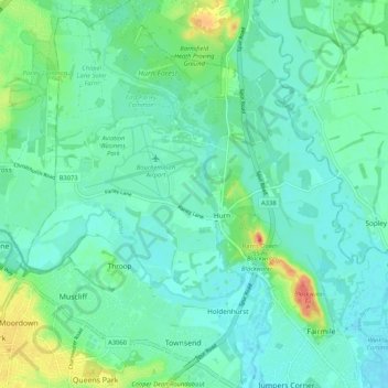
Nombre: Mapa topográfico Hurn, altitud, relieve.
Altitud media: 12 m
Altitud mínima: -1 m
Altitud máxima: 54 m
Otros mapas topográficos
Haga clic en un mapa para ver su topografía, su altitud y su relieve.
East Parley Common
United Kingdom > England > Bournemouth, Christchurch and Poole > Hurn
Altitud media: 13 m
Hengistbury Head
United Kingdom > England > Bournemouth, Christchurch and Poole > Bournemouth
In 1910 the first international aviation meeting ever held in Britain took place on a specially laid out aerodrome consisting of a mile of grassland between the "Double Dykes" and the nearby village of Tuckton. About twenty pioneer aviators from around the world participated in various competitions including…
Altitud media: 0 m
Throop
United Kingdom > England > Bournemouth, Christchurch and Poole > Bournemouth
Altitud media: 13 m
Kinson
United Kingdom > England > Bournemouth, Christchurch and Poole > Bournemouth
Altitud media: 26 m
Upton Heath Nature Reserve
United Kingdom > England > Bournemouth, Christchurch and Poole > Poole
Altitud media: 40 m
Bear Cross
United Kingdom > England > Bournemouth, Christchurch and Poole > Bournemouth
Altitud media: 30 m
St Catherine's Hill
United Kingdom > England > Bournemouth, Christchurch and Poole > Christchurch
Altitud media: 10 m
Redhill Park
United Kingdom > England > Bournemouth, Christchurch and Poole > Bournemouth > Talbot Village
Altitud media: 33 m
Hamworthy Park
United Kingdom > England > Bournemouth, Christchurch and Poole > Poole
Altitud media: 2 m
Kings Park
United Kingdom > England > Bournemouth, Christchurch and Poole > Bournemouth
Altitud media: 31 m
Island in the Stour
United Kingdom > England > Bournemouth, Christchurch and Poole > Poole > Merley
Altitud media: 28 m
Holdenhurst
United Kingdom > England > Bournemouth, Christchurch and Poole > Bournemouth
Altitud media: 12 m