
Mapa topográfico Essen
Mapa interactivo
Haga clic en el mapa para ver la altitud.
Acerca de este mapa
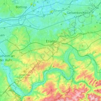
Nombre: Mapa topográfico Essen, altitud, relieve.
Lugar: Essen, North Rhine – Westphalia, Germany (51.34757 6.89434 51.53423 7.13765)
Altitud media: 86 m
Altitud mínima: 27 m
Altitud máxima: 254 m
The lowest point can be found in the northern borough of Karnap at 26.5 m (86.9 ft), the highest point in the borough of Heidhausen at 202.5 m (664 ft). The average elevation is 116 m (381 ft).
Otros mapas topográficos
Haga clic en un mapa para ver su topografía, su altitud y su relieve.
Linnep
Germany > North Rhine – Westphalia > Kreis Mettmann > Ratingen
Linnep, Lintorf/Breitscheid, Ratingen, Kreis Mettmann, North Rhine – Westphalia, 40885, Germany
Altitud media: 83 m
Ruppichteroth
Germany > North Rhine – Westphalia > Rhein-Sieg-Kreis
Ruppichteroth, Rhein-Sieg-Kreis, North Rhine – Westphalia, 53809, Germany
Altitud media: 216 m
Brandenberg
Germany > North Rhine – Westphalia > Kreis Düren > Hürtgenwald
Brandenberg, Hürtgenwald, Kreis Düren, North Rhine – Westphalia, 52393, Germany
Altitud media: 324 m
Würselen
Germany > North Rhine – Westphalia > Städteregion Aachen
Würselen, Städteregion Aachen, North Rhine – Westphalia, 52146, Germany
Altitud media: 172 m
Bottrop
Germany > North Rhine – Westphalia
Bottrop, North Rhine – Westphalia, Germany
Altitud media: 53 m
Kamp-Lintfort
Germany > North Rhine – Westphalia > Kreis Wesel
Kamp-Lintfort, Kreis Wesel, North Rhine – Westphalia, 47475, Germany
Altitud media: 28 m