
Haz una donación
Mapa topográfico Banner Elk
Haga clic en el mapa para ver la altitud.
Haz una donación
Banner Elk
Banner Elk is located in North America's humid continental climate zone due to its elevation, which gives it a climate more like that of Altoona, Pennsylvania, than Asheville, North Carolina, during the winter. During the summer the temperatures are much like a mountain lake town in New Hampshire. The town typically has cold, snowy winters and mild summers.
Haz una donación
Acerca de este mapa
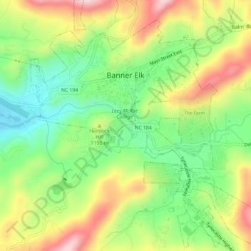
Nombre: Mapa topográfico Banner Elk, altitud, relieve.
Lugar: Banner Elk, Avery County, North Carolina, United States (36.13897 -81.88774 36.17356 -81.84810)
Altitud media: 1,164 m
Altitud mínima: 1,036 m
Altitud máxima: 1,332 m
Haz una donación
Otros mapas topográficos
Haga clic en un mapa para ver su topografía, su altitud y su relieve.
Haz una donación
Haz una donación
Sugar Mountain
United States > North Carolina > Avery County > Sugar Mountain
Sugar Mountain is a mountain in the North Carolina High Country and wholly in the Pisgah National Forest. Its elevation reaches 5,236 feet (1,596 m) and is split along the Eastern Continental Divide, generating feeder streams for the Linville, Elk, and North Toe rivers. On its north slope resides the Village…
Altitud media: 1,385 m
Beech Mountain
United States > North Carolina > Avery County > Beech Mountain
Beech Mountain is a mountain in the North Carolina High Country and wholly in the Pisgah National Forest. Its elevation reaches 5,506 feet (1,657 m) and generates feeder streams for the Elk River. Nestled on the top is the Town of Beech Mountain.
Altitud media: 1,433 m
Haz una donación