
Mapa topográfico Doha
Mapa interactivo
Haga clic en el mapa para ver la altitud.
Acerca de este mapa
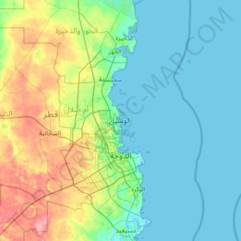
Nombre: Mapa topográfico Doha, altitud, relieve.
Lugar: Doha, Qatar (25.15054 51.39577 25.68320 52.41712)
Altitud media: 16 m
Altitud mínima: -2 m
Altitud máxima: 79 m
Doha is located on the central-east portion of Qatar, bordered by the Persian Gulf on its coast. Its elevation is 10 m (33 ft). Doha is highly urbanized. Land reclamation off the coast has added 400 hectares of land and 30 km of coastline. Half of the 22 km² of surface area which Hamad International Airport was constructed on was reclaimed land. The geology of Doha is primarily composed of weathered unconformity on the top of the Eocene period Dammam Formation, forming dolomitic limestone.
Otros mapas topográficos
Haga clic en un mapa para ver su topografía, su altitud y su relieve.
Oxygen Park
Oxygen Park, Education City, Al Rayyan, Qatar
Altitud media: 13 m
al Koot Fort
al Koot Fort, Jasim Bin Mohammed Street, Al Jasra, Doha, Qatar
Altitud media: 9 m
Fereej Al Manseer
Fereej Al Manseer, Al Rayyan, Ar Rayyan, 93035, Qatar
Altitud media: 26 m
Qurayn Abu al Bawl
Qurayn Abu al Bawl, Jariyan Al Batnah, Qatar
Altitud media: 76 m