
Mapa topográfico Weimar
Mapa interactivo
Haga clic en el mapa para ver la altitud.
Acerca de este mapa
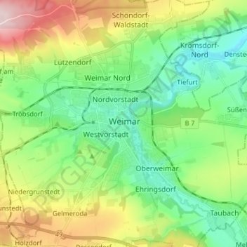
Nombre: Mapa topográfico Weimar, altitud, relieve.
Lugar: Weimar, Thuringia, 99423, Germany (50.94028 11.28909 51.02028 11.36909)
Altitud media: 282 m
Altitud mínima: 190 m
Altitud máxima: 468 m
Weimar is situated within the valley of Ilm river, a tributary of Saale river on the southern border of the Thuringian Basin, a fertile agricultural area between the Harz mountains 70 km (43 mi) in the north and the Thuringian Forest 50 km (31 mi) in the southwest. The municipal terrain is hilly; the height of the city centre in Ilm valley is approximately 200 m of elevation. To the north, the terrain rises to Ettersberg, the city's backyard mountain, 482 m in height. The range of hills in the south of Weimar rises up to 370 m and is part of the Ilm Saale Plate Muschelkalk formation. The eastern, central and western parts of the municipal territory are in agricultural use, whereas the Ettersberg and some southern areas are wooded.