
Mapa topográfico Glendive
Mapa interactivo
Haga clic en el mapa para ver la altitud.
Acerca de este mapa
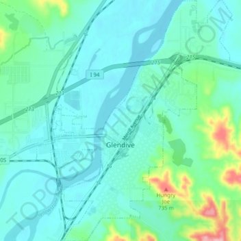
Nombre: Mapa topográfico Glendive, altitud, relieve.
Lugar: Glendive, Dawson County, Montana, 59330, United States (47.08425 -104.73924 47.13675 -104.67647)
Altitud media: 647 m
Altitud mínima: 620 m
Altitud máxima: 771 m
The elevation of the city is 2,064 feet (629 m). Interstate 94 passes through town with access from exits 215, 224 and 231. Montana Highway 16 begins in West Glendive. The Yellowstone River cuts through town.
Otros mapas topográficos
Haga clic en un mapa para ver su topografía, su altitud y su relieve.
West Glendive
United States > Montana > Dawson County
West Glendive, Dawson County, Montana, United States
Altitud media: 652 m
Makoshika State Park
United States > Montana > Dawson County > Glendive
Makoshika State Park, 1301, Glendive, Dawson County, Montana, 59330, United States
Altitud media: 701 m
Makoshika State Park
United States > Montana > Dawson County > Glendive
Makoshika State Park, Glendive, Dawson County, Montana, United States
Altitud media: 698 m