
Mapa topográfico Basin
Mapa interactivo
Haga clic en el mapa para ver la altitud.
Acerca de este mapa
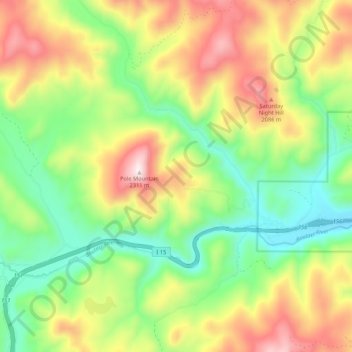
Nombre: Mapa topográfico Basin, altitud, relieve.
Lugar: Basin, Jefferson County, Montana, 59631, United States (46.24418 -112.34150 46.31794 -112.24101)
Altitud media: 1,892 m
Altitud mínima: 1,603 m
Altitud máxima: 2,304 m
Basin, in Jefferson County, is part of the Helena Micropolitan Statistical Area. It lies at an elevation of 5,364 feet (1,635 m) above sea level along Interstate 15 about 30 miles (48 km) by road north of Butte and 38 miles (61 km) south of Helena in a narrow canyon. The community is largely surrounded by the Beaverhead-Deerlodge National Forest. Basin Creek flows south through the center of Basin to its confluence with a larger stream, the Boulder River, which flows east along the south side of Basin. No paved roads except the interstate highway, which runs along the river canyon, connect Basin to other towns. About 10 miles (16 km) upstream on Basin Creek lies the Continental Divide. According to the United States Census Bureau, the CDP has a total area of 12.7 square miles (33.0 km2), all land.
Otros mapas topográficos
Haga clic en un mapa para ver su topografía, su altitud y su relieve.
Mount Pisgah
United States > Montana > Jefferson County
Mount Pisgah, Jefferson County, Montana, United States
Altitud media: 2,265 m