
Mapa topográfico Dover
Mapa interactivo
Haga clic en el mapa para ver la altitud.
Acerca de este mapa
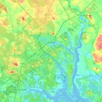
Nombre: Mapa topográfico Dover, altitud, relieve.
Lugar: Dover, Strafford County, New Hampshire, 03820, United States (43.11764 -70.96161 43.25498 -70.81902)
Altitud media: 31 m
Altitud mínima: -9 m
Altitud máxima: 106 m
According to the United States Census Bureau, the city has a total area of 29.0 square miles (75.2 km2), of which 26.7 square miles (69.2 km2) are land and 2.3 square miles (6.0 km2) are water, comprising 7.97% of the city. Dover is drained by the Cochecho and Bellamy rivers, both of which flow into the tidal Piscataqua River, which forms the city's eastern boundary and the New Hampshire–Maine border. Long Hill, elevation greater than 300 feet (91 m) above sea level and located 3 miles (5 km) northwest of the city center, is the highest point in Dover. Garrison Hill, elevation approximately 290 ft (88 m), is a prominent hill rising directly above the center city, with a park and lookout tower on top.
Otros mapas topográficos
Haga clic en un mapa para ver su topografía, su altitud y su relieve.
Rochester
United States > New Hampshire > Strafford County
Rochester, Strafford County, New Hampshire, United States
Altitud media: 90 m
New Durham
United States > New Hampshire > Strafford County
New Durham, Strafford County, New Hampshire, 03855, United States
Altitud media: 228 m
Barrington
United States > New Hampshire > Strafford County
Barrington, Strafford County, New Hampshire, United States
Altitud media: 93 m
Somersworth
United States > New Hampshire > Strafford County
Somersworth, Strafford County, New Hampshire, 03878, United States
Altitud media: 56 m
Hornetown
United States > New Hampshire > Strafford County > Farmington
Hornetown, Farmington, Strafford County, New Hampshire, United States
Altitud media: 225 m
Dover
United States > New Hampshire > Strafford County > Dover
Dover, Strafford County, New Hampshire, 03820, United States
Altitud media: 52 m
Middleton
United States > New Hampshire > Strafford County
Middleton, Strafford County, New Hampshire, 03887, United States
Altitud media: 233 m
Milton
United States > New Hampshire > Strafford County
Milton, Strafford County, New Hampshire, United States
Altitud media: 183 m
Madbury
United States > New Hampshire > Strafford County
Madbury, Strafford County, New Hampshire, 03823, United States
Altitud media: 34 m
Farmington
United States > New Hampshire > Strafford County
Farmington, Strafford County, New Hampshire, 03835, United States
Altitud media: 168 m
Rochester
United States > New Hampshire > Strafford County > Rochester
Rochester, Strafford County, New Hampshire, 03867, United States
Altitud media: 118 m
Piper Mountain
United States > New Hampshire > Strafford County > Middleton
Piper Mountain, Middleton, Strafford County, New Hampshire, 03887, United States
Altitud media: 216 m
Strafford
United States > New Hampshire > Strafford County
Strafford, Strafford County, New Hampshire, United States
Altitud media: 202 m
Durham
United States > New Hampshire > Strafford County
Durham, Strafford County, New Hampshire, 03824, United States
Altitud media: 23 m