Geolocalizar

Mapa topográfico Valentine

Mapa interactivo

Haga clic en el mapa para ver la altitud.

Acerca de este mapa

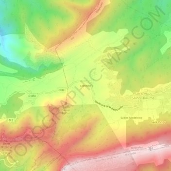
Nombre: Mapa topográfico Valentine, altitud, relieve.

Lugar: Valentine, Plan-d'Aups-Sainte-Baume, Brignoles, Var, Provence-Alpes-Côte d'Azur, France métropolitaine, 83640, France (43.31166 5.67611 43.35166 5.71611)

Altitud media: 688 m

Altitud mínima: 293 m

Altitud máxima: 1,042 m

Otros mapas topográficos

Haga clic en un mapa para ver su topografía, su altitud y su relieve.

Saint-Pilon

France > Provence-Alpes-Côte d'Azur > Var > Plan-d'Aups-Sainte-Baume

Saint-Pilon, Plan-d'Aups-Sainte-Baume, Brignoles, Var, Provence-Alpes-Côte d'Azur, France métropolitaine, 83640, France

Altitud media: 764 m

Le Plan

France > Provence-Alpes-Côte d'Azur > Var > Plan-d'Aups-Sainte-Baume

Le Plan, Plan-d'Aups-Sainte-Baume, Brignoles, Var, Provence-Alpes-Côte d'Azur, France métropolitaine, 83640, France

Altitud media: 720 m

Le Corps-de-Ville

France > Provence-Alpes-Côte d'Azur > Var > Plan-d'Aups-Sainte-Baume

Le Corps-de-Ville, Plan-d'Aups-Sainte-Baume, Brignoles, Var, Provence-Alpes-Côte d'Azur, France métropolitaine, 83640, France

Altitud media: 728 m

Sainte-Madeleine

France > Provence-Alpes-Côte d'Azur > Var > Plan-d'Aups-Sainte-Baume

Sainte-Madeleine, Plan-d'Aups-Sainte-Baume, Brignoles, Var, Provence-Alpes-Côte d'Azur, France métropolitaine, 83640, France

Altitud media: 741 m

Réserve biologique dirigée de Sainte-Baume

France > Provence-Alpes-Côte d'Azur > Var > Plan-d'Aups-Sainte-Baume

Réserve biologique dirigée de Sainte-Baume, La Voie Royale, Plan-d'Aups-Sainte-Baume, Brignoles, Var, Provence-Alpes-Côte d'Azur, France métropolitaine, 83640, France

Altitud media: 757 m

Saint-Victor

France > Provence-Alpes-Côte d'Azur > Var > Plan-d'Aups-Sainte-Baume

Saint-Victor, Plan-d'Aups-Sainte-Baume, Brignoles, Var, Provence-Alpes-Côte d'Azur, France métropolitaine, 83640, France

Altitud media: 736 m