
Gracias por apoyar a este sitio ❤️
Haz una donación
Haz una donación
Mapa topográfico Menstrie
Haga clic en el mapa para ver la altitud.
Gracias por apoyar a este sitio ❤️
Haz una donación
Haz una donación
Menstrie
Menstrie stands on the carse or flood plain of the River Devon, between 10 and 20 metres altitude above sea level. It is roughly astride the Ochil Fault whose movement gave rise to the dramatic southern scarp of the Ochils but which is now almost quiescent.
Gracias por apoyar a este sitio ❤️
Haz una donación
Haz una donación
Acerca de este mapa
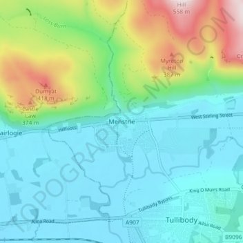
Nombre: Mapa topográfico Menstrie, altitud, relieve.
Lugar: Menstrie, Clackmannanshire, Scotland, FK11 7BL, United Kingdom (56.13142 -3.87377 56.17142 -3.83377)
Altitud media: 129 m
Altitud mínima: 3 m
Altitud máxima: 527 m
Gracias por apoyar a este sitio ❤️
Haz una donación
Haz una donación
Otros mapas topográficos
Haga clic en un mapa para ver su topografía, su altitud y su relieve.