
Mapa topográfico Spences Bridge
Mapa interactivo
Haga clic en el mapa para ver la altitud.
Acerca de este mapa
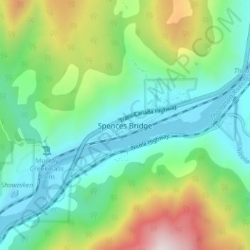
Nombre: Mapa topográfico Spences Bridge, altitud, relieve.
Altitud media: 495 m
Altitud mínima: 213 m
Altitud máxima: 1,195 m
Spences Bridge's location is mountainous, with higher elevations part of the Interior Plateau. The east side of the Fraser here is part of the Clear Range, a mountainous southwards extension of the Fraser Plateau located in the angle of the Thompson and Fraser Rivers. Arthur Seat lies in that range on the west side of Spences Bridge, and was named by pioneer John Murray for Arthur's Seat in Edinburgh, Scotland.
Otros mapas topográficos
Haga clic en un mapa para ver su topografía, su altitud y su relieve.
Walhachin
Canada > British Columbia > Thompson-Nicola Regional District > Area I (Blue Sky Country)
Walhachin, Area I (Blue Sky Country), Thompson-Nicola Regional District, British Columbia, Canada
Altitud media: 438 m
Barnes Lake
Canada > British Columbia > Thompson-Nicola Regional District > Area I (Blue Sky Country)
Barnes Lake, Area I (Blue Sky Country), Thompson-Nicola Regional District, British Columbia, Canada
Altitud media: 752 m
Shaw Springs
Canada > British Columbia > Thompson-Nicola Regional District > Area I (Blue Sky Country)
Shaw Springs, Area I (Blue Sky Country), Thompson-Nicola Regional District, British Columbia, Canada
Altitud media: 472 m