
Mapa topográfico Blacksburg
Mapa interactivo
Haga clic en el mapa para ver la altitud.
Acerca de este mapa
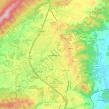
Nombre: Mapa topográfico Blacksburg, altitud, relieve.
Lugar: Blacksburg, Montgomery County, Virginia, United States (37.18389 -80.48068 37.27693 -80.37912)
Altitud media: 621 m
Altitud mínima: 440 m
Altitud máxima: 860 m
In the mid-1600s, English colonists were still uncertain of what lay beyond the Allegheny Mountains, whose topography and possession by native inhabitants, Tutelo-speaking tribes, were a barrier to expanded settlement by the Colony of Virginia. Abraham Wood, who commanded Fort Henry on the frontier (now the site of Petersburg, Virginia), and operated an Indian trading post nearby, organized several expeditions to explore farther west. A passage over the ridge was finally found in 1671 when explorers Batts and Fallam, sent by Wood, reached the present-day location of Blacksburg, Virginia. Their expedition followed Stroubles Creek, through the current locations of the town and campus of Virginia Tech, to what they named Wood's River.
Otros mapas topográficos
Haga clic en un mapa para ver su topografía, su altitud y su relieve.
Southgate
United States > Virginia > Montgomery County > Blacksburg > Southgate
Southgate, Blacksburg, Montgomery County, Virginia, 24061-9517, United States
Altitud media: 643 m
Ramble Ridge
United States > Virginia > Montgomery County > Blacksburg > Ramble Ridge
Ramble Ridge, Blacksburg, Montgomery County, Virginia, 24061-9517, United States
Altitud media: 632 m
Christiansburg
United States > Virginia > Montgomery County > Christiansburg
Christiansburg, Montgomery County, Virginia, United States
Altitud media: 620 m