
Gracias por apoyar a este sitio ❤️
Haz una donación
Haz una donación
Mapa topográfico Sonamarg
Haga clic en el mapa para ver la altitud.
Gracias por apoyar a este sitio ❤️
Haz una donación
Haz una donación
Sonamarg
The hill station is situated in the Kashmir Valley, at an altitude of 2,730 metres (8,960 ft) Combined with the alpine meadows that bloom in the summer as well as rivers and lakes stocked with fish, Sonamarg is a notable tourist destination in Jammu and Kashmir.
Gracias por apoyar a este sitio ❤️
Haz una donación
Haz una donación
Acerca de este mapa
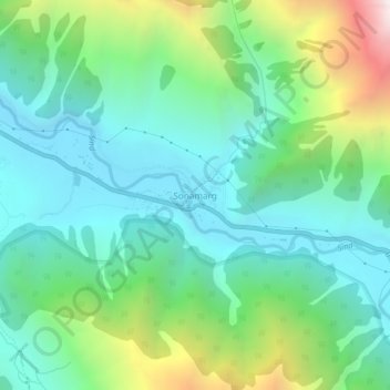
Nombre: Mapa topográfico Sonamarg, altitud, relieve.
Lugar: Sonamarg, Kangan, Ganderbal, Jammu and Kashmir, India (34.28239 75.27656 34.32239 75.31656)
Altitud media: 3,068 m
Altitud mínima: 2,639 m
Altitud máxima: 4,240 m
Gracias por apoyar a este sitio ❤️
Haz una donación
Haz una donación