Geolocalizar

Mapa topográfico Putanges-Pont-Écrepin

Mapa interactivo

Haga clic en el mapa para ver la altitud.

Acerca de este mapa

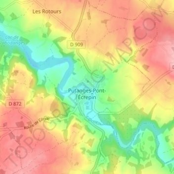
Nombre: Mapa topográfico Putanges-Pont-Écrepin, altitud, relieve.

Lugar: Putanges-Pont-Écrepin, Putanges-le-Lac, Argentan, Orne, Normandie, France métropolitaine, 61210, France (48.74558 -0.28373 48.78478 -0.22075)

Altitud media: 186 m

Altitud mínima: 119 m

Altitud máxima: 248 m

Cependant, il faut prendre put au sens non pas de « sale », mais plutôt de « mauvais » (signification que sale peut aussi avoir). Deux anciens lieux-dits de Lisieux portent le nom de Putangle (de Puto angulo 1200, Putangle 1267) et Bonangle (Bone Angle 1293, Bon Angle 1326), ce dernier devenu aujourd'hui la rue Bon Ange. Il s'agit de deux coins de l'ancienne île Saint-Dominique sur la Touques, le put angle « mauvais coin » est formé par le coude dangereux ou malcommode de la rivière, et le bon angle « bon coin » s'oppose ainsi à lui. La topographie à Putanges est identique puisqu'il est situé sur une courbe prononcée de l'Orne.

Wikipedia (CC-BY-SA 3.0)

Otros mapas topográficos

Haga clic en un mapa para ver su topografía, su altitud y su relieve.

Le Ray

France > Normandie > Orne > Putanges-le-Lac > La Forêt-Auvray

Le Ray, La Forêt-Auvray, Putanges-le-Lac, Argentan, Orne, Normandie, France métropolitaine, 61210, France

Altitud media: 164 m

La Fresnaye-au-Sauvage

France > Normandie > Orne > Putanges-le-Lac

La Fresnaye-au-Sauvage, Putanges-le-Lac, Argentan, Orne, Normandie, France métropolitaine, 61210, France

Altitud media: 214 m

Rabodanges

France > Normandie > Orne > Putanges-le-Lac

Rabodanges, Putanges-le-Lac, Argentan, Orne, Normandie, France métropolitaine, 61210, France

Altitud media: 188 m

Les Courtils

France > Normandie > Orne > Putanges-le-Lac > Putanges-Pont-Écrepin

Les Courtils, Putanges-Pont-Écrepin, Putanges-le-Lac, Argentan, Orne, Normandie, France métropolitaine, 61210, France

Altitud media: 186 m

Les Rotours

France > Normandie > Orne > Putanges-le-Lac

Les Rotours, Putanges-le-Lac, Argentan, Orne, Normandie, France métropolitaine, 61210, France

Altitud media: 191 m

Le Hamel

France > Normandie > Orne > Putanges-le-Lac > La Forêt-Auvray > Le Hamel

Le Hamel, La Forêt-Auvray, Putanges-le-Lac, Argentan, Orne, Normandie, France métropolitaine, 61210, France

Altitud media: 173 m

Le Perrey

France > Normandie > Orne > Putanges-le-Lac > Rabodanges

Le Perrey, Rabodanges, Putanges-le-Lac, Argentan, Orne, Normandie, France métropolitaine, 61210, France

Altitud media: 177 m

Le Chenay

France > Normandie > Orne > Putanges-le-Lac > Putanges-Pont-Écrepin

Le Chenay, Putanges-Pont-Écrepin, Putanges-le-Lac, Argentan, Orne, Normandie, France métropolitaine, 61210, France

Altitud media: 188 m

Saint-Aubert-sur-Orne

France > Normandie > Orne > Putanges-le-Lac

Saint-Aubert-sur-Orne, Putanges-le-Lac, Argentan, Orne, Normandie, France métropolitaine, 61210, France

Altitud media: 200 m

Sainte-Croix-sur-Orne

France > Normandie > Orne > Putanges-le-Lac

Sainte-Croix-sur-Orne, Putanges-le-Lac, Argentan, Orne, Normandie, France métropolitaine, 61210, France

Altitud media: 186 m