
Haz una donación
Mapa topográfico Astley Town
Haga clic en el mapa para ver la altitud.
Haz una donación
Acerca de este mapa
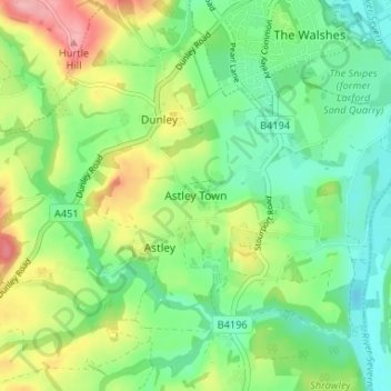
Nombre: Mapa topográfico Astley Town, altitud, relieve.
Altitud media: 56 m
Altitud mínima: 11 m
Altitud máxima: 138 m
Haz una donación
Otros mapas topográficos
Haga clic en un mapa para ver su topografía, su altitud y su relieve.
Broadheath
United Kingdom > England > Worcestershire > Malvern Hills > Lower Broadheath
Altitud media: 44 m
Haz una donación
Haz una donación
West Malvern
United Kingdom > England > Worcestershire > Malvern Hills
West Malvern is a village and a civil parish on the west side of the north part of the Malvern Hills, on the western edge of Worcestershire, England. It has become effectively a suburb of Malvern and part of an urban area often called The Malverns, locally administered by Malvern Hills District Council and its…
Altitud media: 198 m
Haz una donación
Haz una donación
Haz una donación
Haz una donación
Haz una donación
Haz una donación
Haz una donación
Knighton on Teme
United Kingdom > England > Worcestershire > Malvern Hills > Knighton on Teme
Altitud media: 82 m
Haz una donación
Haz una donación