
Gracias por apoyar a este sitio ❤️
Haz una donación
Haz una donación
Mapa topográfico Les Hayons
Haga clic en el mapa para ver la altitud.
Gracias por apoyar a este sitio ❤️
Haz una donación
Haz una donación
Acerca de este mapa
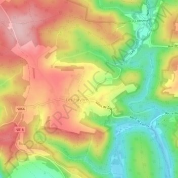
Nombre: Mapa topográfico Les Hayons, altitud, relieve.
Altitud media: 331 m
Altitud mínima: 231 m
Altitud máxima: 424 m
Gracias por apoyar a este sitio ❤️
Haz una donación
Haz una donación
Otros mapas topográficos
Haga clic en un mapa para ver su topografía, su altitud y su relieve.
Bouillon
Belgique > Luxembourg > Neufchâteau > Bouillon
Entourée de forêts, la ville s’étend dans et autour d’un méandre accentué de la Semois, un affluent de la Meuse. L'altitude y est d'environ 220 mètres. Elle est desservie par la route nationale 83 menant à Arlon, route qui borde la ville à l’est et qui se confond sur le territoire communal avec…
Altitud media: 338 m
Gracias por apoyar a este sitio ❤️
Haz una donación
Haz una donación