
Mapa topográfico Wausau
Mapa interactivo
Haga clic en el mapa para ver la altitud.
Acerca de este mapa
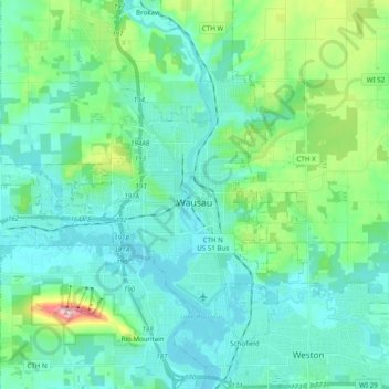
Nombre: Mapa topográfico Wausau, altitud, relieve.
Lugar: Wausau, Marathon County, Wisconsin, United States (44.91855 -89.76793 45.00644 -89.57292)
Altitud media: 394 m
Altitud mínima: 351 m
Altitud máxima: 585 m
According to the United States Census Bureau, the city has a total area of 20.33 square miles (52.7 km2), of which 19.22 square miles (49.8 km2) is land and 1.11 square miles (2.9 km2) is water. The city is located at an altitude of 1,195 feet (364 m). Wausau is close to the center of the northern half of the Western Hemisphere. Just west of Wausau, 45°N meets 90°W (45°N 90°W / 45°N 90°W / 45; -90), which is exactly halfway between the equator and the north pole and a quarter of the way around the world from the prime meridian.
Otros mapas topográficos
Haga clic en un mapa para ver su topografía, su altitud y su relieve.
Village of Weston
United States > Wisconsin > Marathon County
Village of Weston, Marathon County, Wisconsin, 54476, United States
Altitud media: 371 m
Schofield
United States > Wisconsin > Marathon County
Schofield, Marathon County, Wisconsin, United States
Altitud media: 364 m
Town of Johnson
United States > Wisconsin > Marathon County
Town of Johnson, Marathon County, Wisconsin, United States
Altitud media: 433 m
Bypass Channel Wisconsin River
United States > Wisconsin > Marathon County > Wausau
Bypass Channel Wisconsin River, River District, Wausau, Marathon County, Wisconsin, 54403, United States
Altitud media: 371 m
Athens
United States > Wisconsin > Marathon County > Athens
Athens, Marathon County, Wisconsin, United States
Altitud media: 420 m
Knowlton
United States > Wisconsin > Marathon County
Knowlton, Marathon County, Wisconsin, United States
Altitud media: 346 m
Rib Mountain
United States > Wisconsin > Marathon County > Rib Mountain
Rib Mountain, Town of Stettin, Marathon County, Wisconsin, 54401, United States
Altitud media: 380 m