
Gracias por apoyar a este sitio ❤️
Haz una donación
Haz una donación
Mapa topográfico Nelson Forks
Haga clic en el mapa para ver la altitud.
Gracias por apoyar a este sitio ❤️
Haz una donación
Haz una donación
Acerca de este mapa
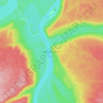
Nombre: Mapa topográfico Nelson Forks, altitud, relieve.
Altitud media: 297 m
Altitud mínima: 236 m
Altitud máxima: 376 m
Gracias por apoyar a este sitio ❤️
Haz una donación
Haz una donación
Otros mapas topográficos
Haga clic en un mapa para ver su topografía, su altitud y su relieve.
Muncho Lake
Canada > British Columbia > Northern Rockies Regional Municipality
The lake is part of the Muncho Lake Provincial Park and located at kilometre 681 (mile 423) of the Alaska Highway. The lake is about 12 km (7.5 mi) long and its width varies. It reaches a maximum depth of 110 m (360 ft). The surrounding peaks (the Terminal Range of the Muskwa Ranges to the west and the…
Altitud media: 1,322 m