
Mapa topográfico Mount Caubvick
Haga clic en el mapa para ver la altitud.
Acerca de este mapa
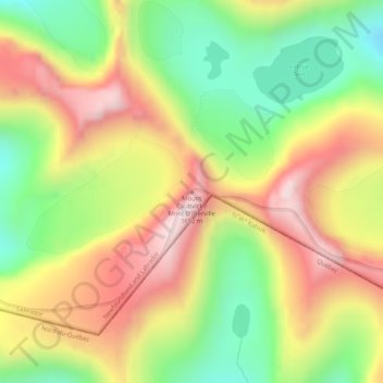
Nombre: Mapa topográfico Mount Caubvick, altitud, relieve.
Lugar: Mount Caubvick, Labrador, Newfoundland and Labrador, Canada (58.88723 -63.71280 58.88733 -63.71270)
Altitud media: 1,272 m
Altitud mínima: 972 m
Altitud máxima: 1,593 m
Otros mapas topográficos
Haga clic en un mapa para ver su topografía, su altitud y su relieve.
Bell Island
Canada > Newfoundland and Labrador > Wabana
The coast is very rocky and consists almost entirely of steep cliffs tens of meters high that tower up to 45 kilometres (28 mi) above sea level. The island, which continues to gain in altitude especially close to the coastline, reaches a maximum height of 148 metres (486 ft). Because the central part of the…
Altitud media: 30 m
Clarenville
Canada > Newfoundland and Labrador
The Clarenville area has many of the physical features characteristic of the East Coast of Newfoundland and has a marine climate. It lies along the coastal slopes which rise from the Atlantic Ocean towards the interior central plateau of the island. The dominating physical feature is a ridge of broken peaks…
Altitud media: 102 m