
Gracias por apoyar a este sitio ❤️
Haz una donación
Haz una donación
Mapa topográfico Glenridding Dodd
Haga clic en el mapa para ver la altitud.
Gracias por apoyar a este sitio ❤️
Haz una donación
Haz una donación
Glenridding Dodd
Glenridding Dodd (the rounded hill above Glenridding) is a small fell in the English Lake District, at the end of a ridge descending from the Helvellyn range in the Eastern Fells. It stands above the village of Glenridding and on the western shore of Ullswater. Although small and not of great elevation, its top is a fine viewpoint for Ullswater and for the fells clustered round the valleys above Patterdale.
Gracias por apoyar a este sitio ❤️
Haz una donación
Haz una donación
Acerca de este mapa
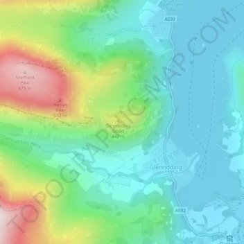
Nombre: Mapa topográfico Glenridding Dodd, altitud, relieve.
Altitud media: 298 m
Altitud mínima: 143 m
Altitud máxima: 698 m
Gracias por apoyar a este sitio ❤️
Haz una donación
Haz una donación