
Mapa topográfico Tiger
Mapa interactivo
Haga clic en el mapa para ver la altitud.
Acerca de este mapa
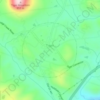
Nombre: Mapa topográfico Tiger, altitud, relieve.
Lugar: Tiger, Rabun County, Georgia, United States (34.83841 -83.44209 34.85320 -83.42411)
Altitud media: 608 m
Altitud mínima: 506 m
Altitud máxima: 859 m
Tiger lies in the extreme northeastern part of the state, just a few miles west of the Georgia-South Carolina border, and a few miles south of the Georgia-North Carolina border. The town's elevation is 1,962 feet (598 m), with several wooded hilltops reaching elevations of 2,100 to 2,200 feet. The town sits at the base of 2,856-foot Tiger Mountain, a prominent Blue Ridge Mountain peak.
Otros mapas topográficos
Haga clic en un mapa para ver su topografía, su altitud y su relieve.
Dillard
United States > Georgia > Rabun County
Dillard, Rabun County, Georgia, United States
Altitud media: 691 m
Sky Valley
United States > Georgia > Rabun County
Sky Valley, Rabun County, Georgia, 30537, United States
Altitud media: 973 m
Clayton
United States > Georgia > Rabun County > Clayton
Clayton, Rabun County, Georgia, 30525, United States
Altitud media: 634 m
Black Rock Mountain State Park
United States > Georgia > Rabun County
Black Rock Mountain State Park, Rabun County, Georgia, 30525, United States
Altitud media: 869 m