
Mapa topográfico Dymock
Haga clic en el mapa para ver la altitud.
Acerca de este mapa
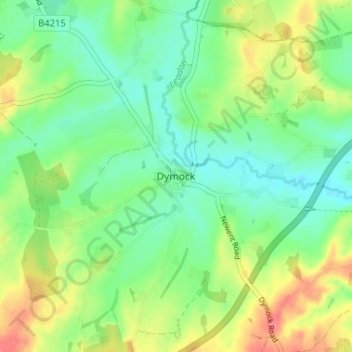
Nombre: Mapa topográfico Dymock, altitud, relieve.
Altitud media: 50 m
Altitud mínima: 26 m
Altitud máxima: 90 m
Otros mapas topográficos
Haga clic en un mapa para ver su topografía, su altitud y su relieve.
Newent Woods
United Kingdom > England > Gloucestershire > Forest of Dean > May Hill
Altitud media: 157 m
Lydney Harbour
United Kingdom > England > Gloucestershire > Forest of Dean > Lydney > Naas
Altitud media: 7 m
Land Grove
United Kingdom > England > Gloucestershire > Forest of Dean > Mitcheldean
Altitud media: 157 m
Cinderford
United Kingdom > England > Gloucestershire > Forest of Dean > Littledean
Altitud media: 173 m