
Gracias por apoyar a este sitio ❤️
Haz una donación
Haz una donación
Mapa topográfico John Gamble Park
Haga clic en el mapa para ver la altitud.
Gracias por apoyar a este sitio ❤️
Haz una donación
Haz una donación
Acerca de este mapa
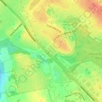
Nombre: Mapa topográfico John Gamble Park, altitud, relieve.
Lugar: John Gamble Park, Hanlon Creek, Guelph, Ontario, Canada (43.50454 -80.23384 43.50709 -80.23042)
Altitud media: 327 m
Altitud mínima: 301 m
Altitud máxima: 347 m
Gracias por apoyar a este sitio ❤️
Haz una donación
Haz una donación
Otros mapas topográficos
Haga clic en un mapa para ver su topografía, su altitud y su relieve.
Guelph
This region of Ontario has cold winters and warm, humid summers, falling into the Köppen climate classification Dfb zone, with moderately high rainfall and snowfall. It is generally a couple of degrees cooler than lower elevation regions on the Great Lakes shorelines, especially so in winter, the exception…
Altitud media: 344 m