
Gracias por apoyar a este sitio ❤️
Haz una donación
Haz una donación
Mapa topográfico Arnison Crag
Haga clic en el mapa para ver la altitud.
Gracias por apoyar a este sitio ❤️
Haz una donación
Haz una donación
Arnison Crag
Although properly a northeastern ridge of Birks and having little topographical prominence, Arnison Crag was classed as a separate fell by Alfred Wainwright in his Pictorial Guide to the Lakeland Fells. That convention is followed here. In support of his decision he referred to it as ‘a low hill with a summit worthy of a mountain’.
Gracias por apoyar a este sitio ❤️
Haz una donación
Haz una donación
Acerca de este mapa
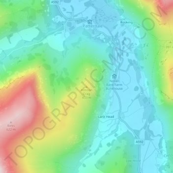
Nombre: Mapa topográfico Arnison Crag, altitud, relieve.
Altitud media: 287 m
Altitud mínima: 147 m
Altitud máxima: 635 m
Gracias por apoyar a este sitio ❤️
Haz una donación
Haz una donación
Otros mapas topográficos
Haga clic en un mapa para ver su topografía, su altitud y su relieve.
Brothers Water
United Kingdom > England > Westmorland and Furness > Patterdale > Hartsop
Altitud media: 298 m
Gracias por apoyar a este sitio ❤️
Haz una donación
Haz una donación