
Mapa topográfico White Plains
Mapa interactivo
Haga clic en el mapa para ver la altitud.
Acerca de este mapa
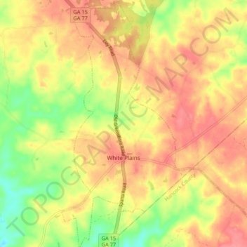
Nombre: Mapa topográfico White Plains, altitud, relieve.
Lugar: White Plains, Greene County, Georgia, United States (33.44757 -83.05588 33.51526 -83.01285)
Altitud media: 193 m
Altitud mínima: 150 m
Altitud máxima: 221 m
Otros mapas topográficos
Haga clic en un mapa para ver su topografía, su altitud y su relieve.
Lake Oconee
United States > Georgia > Greene County > Lake Oconee
Lake Oconee, Greene County, Georgia, United States
Altitud media: 165 m
Greensboro
United States > Georgia > Greene County
Greensboro, Greene County, Georgia, United States
Altitud media: 176 m