
Mapa topográfico Grizedale
Mapa interactivo
Haga clic en el mapa para ver la altitud.
Acerca de este mapa
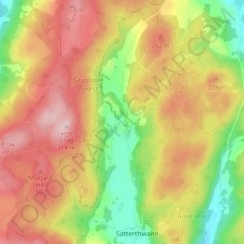
Nombre: Mapa topográfico Grizedale, altitud, relieve.
Altitud media: 186 m
Altitud mínima: 55 m
Altitud máxima: 304 m
Otros mapas topográficos
Haga clic en un mapa para ver su topografía, su altitud y su relieve.
High Dale Park
United Kingdom > England > Westmorland and Furness > Satterthwaite
High Dale Park, Satterthwaite, Westmorland and Furness, England, LA12 8LJ, United Kingdom
Altitud media: 140 m